Volume VIII, Issue VI
The Mapmaker's Ethic I:
Why Accuracy Matters
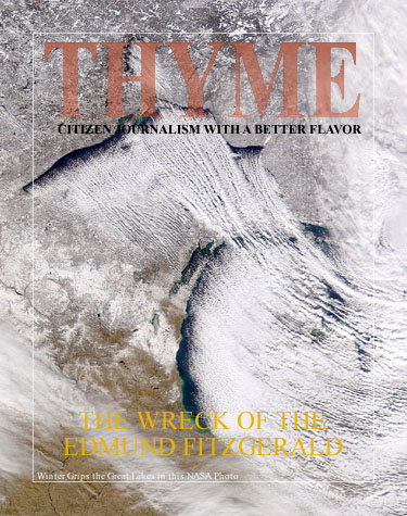
The song still haunts... Gordon Lightfoot's "Ballad of the Edmund Fitzgerald" has an eerie hold on my generation, especially those of us who considered joining the merchant marine or heading to Alaska to seek our fortunes. I never went to sea on the Great Lakes, but the song became a part of me. I have been in storms on the Chesapeake Bay, so I can imagine somewhat the tempest that raged on Superior in mid-November of 1975. The song chronicles the actual voyage of the ship they called the "Big Fitz" as she mysteriously sank that year. The song talks about an extremely violent storm and a "main hatchway" giving in. Many of the crew were the same age as I would have been, had I served among them. That such a great ship would simply vanish, and her crew along with her, was the stuff great mysteries are made of.
Discovery Channel Special on the Edmund Fitzgerald.
The discovery of this special program rekindled my fascination with this great ship and her lost crew. The assumption (in the Lightfoot song, and by the Coast Guard) was that she somehow took water from topside. The Coast Guard asserted that a main hatch was improperly clamped and the ship took water when the storm somehow caused the great hatch to come loose. That is not a very good explanation, however, and the documentary goes into some detail as to what the more likely cause was. The S.S. Edmund Fitzgerald was originally built by the Northwestern Mutual Life Insurance Company of Milwaukee, Wisconsin. The contractor was Great Lakes Engineering Works of Ecorse, Michigan. Her keel was laid on August 7, 1957 as Hull No. 301. Named after the President and Chairman of the Board of Northwestern Mutual, the Edmund Fitzgerald was launched June 8, 1958 at River Rouge, Michigan. Northwestern Mutual placed her under permanent charter to the Columbia Transportation Division of Oglebay Norton Company, Cleveland, Ohio. At 729 feet and 13,632 gross tons she was the largest ship on the Great Lakes, for thirteen years, until 1971.
The huge ship was built for hauling iron ore pellets from Minnesota to the steel mills on the lower Great Lakes. Lake Superior, known to the Native Americans as Gitchee Gumee, is a great inland sea and known for its fierce Winter storms. Shipping on the St. Lawrence Seaway ceased in Winter, but tonnage bonuses, paid to ship's captains and crew, tempted them to try to squeeze in trips even as mid-November's harsh weather approached. So it was that the Fitzgerald, captained by Ernest M. McSorley took on a load of iron ore pellets November 9, 1975 at the Burlington Northern Railroad Dock No.1, Superior, Wisconsin. She was joined by the Arthur Anderson, captained by Bernie Cooper. The two ships set a course for Sault Ste Marie, at the Eastern side of Superior.
A severe storm caught the ships as they made their way down the main shipping channel in the center of the lake. The experienced captains decided to seek a more sheltered route along the Northern shore. The storm became even more violent as two storm cells merged over the great body of water. Large waves rolled up on the ships. As the Fitzgerald approached Caribou Island, her crew was unaware of the dangerous Six Fathom Shoal beneath her. The map was wrong! Pounded by the waves, her captain probably didn't notice the sound of her bottoming out. At 3:30 pm, however, he knew he was taking on water and had some sort of serious damage. McSorley radioed Cooper: "Anderson, this is the Fitzgerald. I have a fence rail down, two vents lost or damaged, and a list. I'm checking down. Will you stay by me till I get to Whitefish?" The Big Fitz slowed her speed and the Anderson began to close the ten mile gap between the two vessels.
Now the injured Fitzgerald set a course for the shelter of Whitefish Bay. As evening set in two monstrous waves rolled over the Anerson. Cooper reports that this happened about 6:55 pm: "Then the Anderson just raised up and shook herself off of all that water - barrooff - just like a big dog. Another wave just like the first one or bigger hit us again. I watched those two waves head down the lake towards the Fitzgerald, and I think those were the two that sent him under." The First Mate of the Anderson, Morgan Clark, kept in radar contact and voice communication with the Fitzgerald:
"Fitzgerald, this is the Anderson. Have you checked down?"
"Yes, we have."
"Fitzgerald, we are about 10 miles behind you, and gaining about 1 1/2 miles per hour. Fitzgerald, there is a target 19 miles ahead of us. So the target would be 9 miles on ahead of you."
"Well, am I going to clear?" McSorley radioed back.
"Yes, he is going to pass to the west of you."
"Well, fine."
"By the way, Fitzgerald, how are you making out with your problems?"
"We are holding our own."
"Okay, fine, I'll be talking to you later." [1.]
But the words, "We are holding our own." spoken around 7:10 pm that evening, were the last communication from the Edmund Fitzgerald. As the seas calmed, an ill-equipped Coast Guard asked the Anderson and several other vessels to search for the Edmund Fitzgerald, but she had vanished. Bits of debris and the twisted half of a lifeboat were all that were spotted. The Gales of November had claimed the great ship and she rested in two parts on the bottom of Lake Superior. Her crew was not to be found.

The map used by Captain Ernest M. McSorley showed Six Fathom Shoal one mile off of its actual position.
A mile's discrepancy in a map! That is the most likely cause of the loss of the Edmund Fitzgerald. No doubt, the error lay in obscurity until violent weather forced two great ships into the area that was wrongly depicted. Comparison has been made to the sinking of the Daniel J. Morell in 1966 where the ship was probably slammed to the bottom by a wave as well and broke in two. One man survived the Morell. [2.] No one survived the Fitzgerald.
The fact that lives depend on their accuracy has always been the ethic guiding the making of maps. In ancient times, the far edges that were not very well charted often bore the legend: "there are monsters!" Such was the way of warning that there was no data for those particular waters. Satellite imagery and sophisticated survey methods have put the monsters to rest, but the need for accuracy is ever greater.
Thy word is a lamp unto my feet, and a light unto my path." -- Psalm 119:105
As a child I became fascinated with maps. Colorful representations of actual faraway places intrigued me. What lay over the horizon waiting to be discovered? Maps pointed the way. Drawings of places unseen, yet when I got my first car, they reliably pointed the way to many adventures. Sometimes it was fun to just get in the car and drive, but if you wanted to go to Rehoboth Beach or Ocean City, you consulted the map!
When I was in high school, I drew a detailed map of Middle Earth that probably still hangs in a closet in my sister's house. It was the accurate representation of a land in a legend, in my adult career I would go on to accurately represent architectural concepts... but somehow I always returned to the map! Researching for author Rob Hewitt, I discovered that you could overlay old maps on modern ones and that they would tell you a story. Modern roads closely followed old turnpikes. Old turnpikes followed the routes of Native American commerce and migration. The overlay of maps told a very true history of the regions they depicted. [3.]
Our studio produced educational maps for the Core Knowledge Foundation and a few years ago I collaborated with artist Kristina Elaine Greer to produce similar maps for the Civitas Foundation in Great Britain as they reproduced the Core Knowledge Series for a British audience. [4.] Over the years, creating maps, there has come to me an awareness of what I would call: The Mapmaker's Ethic! Simply stated it would be thus:
Maps are an important tool for navigating what is often to the user unknown regions. The users' success and ultimately their safety in the journey requires that the mapmaker strive to provide the most accurate depiction his or her art can produce of the ways of travel, their conditions, and possible dangers!
You would never accept as serious advice the notion that you could just get in your car and start driving; for "all roads will get you to Atlanta." Such would be a foolish waste of time and resources. Yet many who would never embarque upon a journey without carefully consulting maps scoff at the notion that there might be solid information about the unseen world as well.
Just as there are a sequence of historical maps and modern ones that tell us important information about the ways we travel, there exists documentation of the unseen world as well. To be sure, some of them are as fanciful as the map of Middle Earth that depicts a land of a story, but are there a succession of historical maps that overlay like those of a historical region, that might indeed point to direction both in our life here and now and in our life to come? And if indeed such charts exist, what is the ethic under which they are produced? Do they build upon prior revelation to provide a complete picture?
If indeed, mankind is eternal, the question is a good one, for if that is indeed so, then most of our 'journey' lies outside of the county we presently reside in! Some will assert that this world is all that is. I would only ask of them: "Are you SURE?" If not, then I would ask them to consider what charts they might need for a longer journey? Some are not ready to consider a journey of such magnitude. They may detrain here if that is so, and are welcome to come aboard again when they so desire. Some may simply be curious. To them I say: "Ride along for a while. It will do you no harm." Finally there are those who feel certain that there is more. To them I say: "Come sit at the head of the train and see where the journey might lead." (to be continued).


No comments:
Post a Comment